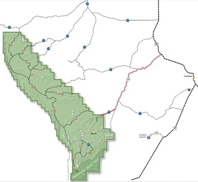
A larger version of this map is available at http://www.fs.usda.gov/main/lincoln/about-forest/districts
General Description
The Guadalupe mountain range is nearly 100 miles long and is characterized by a 30-mile ridge called "The Rim" on the western edge, where elevation drops as much as 2,000 feet, providing spectacular views. The east side drops more gently, but has a number of steep to vertical walled canyons, each with varied riparian environments. Guadalupe Peak, the highest point in Texas at elevation 8,751 feet, is on the southern end of the range in Guadalupe Mountains National Park. The Guadalupe Ranger District is part of a formation known as the Capitan Reef (unrelated to the Capitan Mountains at the north end of the Lincoln National Forest). Over millions of years, vast amounts of limestone dissolved, forming many caves. Dozens of caves in this ranger district and those in Carlsbad Caverns National Park were all formed as a part of this gigantic cave making process.
The surface is generally a Piñon-Juniper woodland. Large portions of the Guadalupe Ranger District are used for cattle grazing.
Fires and torrential rains have damaged the roads and trails in recent years.
Hiking in the Sitting Bull Falls Area
Floods
in Fall 2013 caused extensive damage in the Sitting Bull Falls area.
The recreation site and trails T68
and T68A were
closed to the public. The damage has been repaired and the
recreation site, and trails T68 and T68A aree open. Happy hiking!
The Sitting Bull Falls Recreation Area is a day use area, and camping is never allowed there.
Links to Trails
Listing of Trails by Name
Listing of Trails by Number
Listing of Trails by Location
Updates (most recent first)
Services
Drinking water is available at the Forest Service Admin Center, near milepost 22 on NM137 (Queen Highway). No other services -- gasoline, convenience store, cafe -- are available within the Guadalupe District. The nearest place to obtain these services is Carlsbad, NM.
Roads
Visitors to the Guadalupe RD need to understand that the quality of the roads can limit their access to trails. NM 137 (Queen Highway) is a good paved highway, starting at US 285 and ending at the Texas border, the north entrance to Guadalupe Mountains National park. There is no road through Guadalupe Mountains National Park.
The Sitting Bull Falls highway (County 409, FR276) is paved and provides access to the Sitting Bull Falls recreation site and to most of the lower trailheads for the trails in the Sitting Bulls Falls area. However this road makes use of low water crossings and may be closed in case of rain. For access to the upper trailheads a high clearance 4WD vehicle is recommended, particularly if the roads are wet. Check the Lincoln National Forest website or call the number at the top of this page.
FR540 is a good gravel road, and generally can be traveled in a standard vehicle. FR69/County 412 and FR67 are lesser gravel roads and generally can be traveled in a standard vehicle, although some sections and crossings are rough. Other roads are gravel/dirt and a high clearance/4WD vehicle is recommended.
FR201 connects FR540 to many trails in the Cave Canyon area and is considered impassable for most high clearance 4WDvehicles. FR3008 connects FR540 to the South area trails and is considered impassable for most high clearance 4WD vehicles. A heavy duty high clearance 4WD vehicle or an ATV is recommended for these roads.
Maps
Map. Both maps may be obtained at the Guadalupe RD office, 5203 Buena Vista Drive in Carlsbad. The Forest Service map was
$10 when I bought mine. The Motor Vehicle Users Map was free. The latter map is updated every few months, so be sure to obtain
(and follow) the latest version.
Trail Signs
In the Guadalupe RD, in addition to the usual carsonite and wooden signs, and cairns, trails can be marked in two other ways. Small pieces of sheet metal, usually with orange-white diagonal striping, may be dangling from tree branches or may be nailed to trees or posts. Forest service "hiker signs" may be nailed to trees. Hikers need to remember that the trail path is always perpendicular to the plane of the "hiker sign". Thus a tree with two "hiker signs:, one facing you, and one facing 90 degrees away, tells you that the trail makes a right angle turn.
Lynn Melton is solely responsible for the content of this web page.
Web Page Updated: January 13, 2016
Copyright Lynn Melton 2013
Contact information: LNFTG14@gmail.com